|
|
|
|
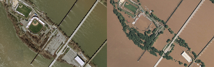
Geographically scaled aerial photographs of Harrisburg, Pennsylvania, before (left) and during a major flood. BAE Systems is generating images such as these through the PAMAP program, which uses the high-tech maps in planning for large events and natural disasters, such as floods. (Photo by BAE Systems) |
BAE Systems has received the next phase of a contract for digital mapping of the Commonwealth of Pennsylvania, the U.S.A. The US$2.7 million contract, administered by Penn State University, will continue the development of base map data supporting the statewide geographic information architecture called the Pennsylvania Map (PAMAP). PAMAP is intended for use by government agencies for emergency planning, homeland security, and other applications.
BAE Systems’s geographically scaled aerial photographs with 2-foot contours of Pennsylvania’s terrain uses orthophotography, light detection, and ranging. Agencies such as the Pennsylvania Emergency Management Agency and its federal counterpart, the Federal Emergency Management Agency (FEMA), will use the high-tech maps in planning for large events and natural disasters, such as floods. “PAMAP is a very valuable tool for anyone doing comprehensive planning, economic development, or supporting public safety in Pennsylvania,“ said Jay Parrish, director and state geologist for the Pennsylvania Department of Conservation and Natural Resources, which is overseeing the project. “PAMAP data has been used to respond to major incidents such as flooding from Hurricane Ivan and for security planning during the Major League Baseball All-Star Game in Pittsburgh.“
This is the fifth year BAE Systems has provided program support to PAMAP. Previously collected images of Pennsylvania are being updated, and concurrently about one-third of the state has been digitally mapped.
For more information, please send your e-mails to swm@infothe.com.
ⓒ2007 www.SecurityWorldMag.com. All rights reserved.
|